Urban Weather Generator 4.1
urban heat island effect modeling software
The new version models multiple typologies and visualize simulation results
UWG code available upon request
Urban Weather Generator [UWG] estimates the hourly urban canopy air temperature and humidity using weather data from a rural weather station. It takes a rural epw file and the *.xml (or *.xlsm) input file, which describes your urban canyon.
The output is a morphed weather file [epw] that captures urban heat island effect and is compatible with many building performance simulation programs.
Instructions
- Obtain a weather file in EnergyPlus [epw] format for a nearby site. DOE provides weather data for over 2,100 locations. Reference sites upwind of your city yields best results
- Create an *.xml or *.xlsm file that describes the morphological and geometric characteristics of the your city and the reference site. Some sample input files are included in the downloaded zip file
- Change the file path corresponding to your own computer in the 'test_run.m' and 'UWG.m' (Section 9) through MATLAB
- Run UWG with your epw and xml (or xlsm) files. The resulting epw file captures urban heat island effect
- Please note that this beta version still requires users to input albedo and emissivity values in the template library before running the simulation. There is currently some problems to run *.xml files, but you can simply modify the code in UWG.m or use *.xlsm files. Thank you for trying it out!
Model Mechanics
The model is based on energy conservation principles and is a bottom-up building stock model. The model takes input parameters that describe urban morphology, geometry, and surface materials. The urban morphology parameters are similar to those used for existing building energy performance simulations. The model variables are described in detail in Model Parameters Description page.
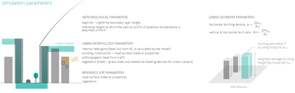
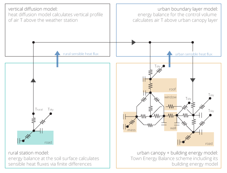
UWG has four coupled modules: the rural station model, the vertical diffusion model,the urban boundary layer model, and the urban canopy + building energy model, and is described in detail in The urban weather generator.
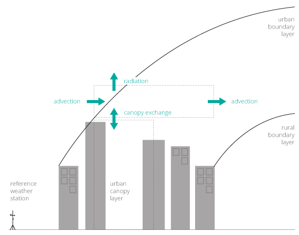
The boundary conditions of the urban canopy and urban boundary layers are shown below. The model estimates building energy consumption at the city scale, specifically accounting for the interactions between buildings and the urban environment.
The model been tested for Basel, Switzerland; Toulouse, France; and several neighborhoods in Singapore [detailed in "Computationally efficient prediction of canopy level urban air temperature at the neighborhood scale", to be published in Urban Climate and summarized here ].
The simulated results are accurate within the range of air temperature variability observed in different locations within the same urban area for all three tested cities. The performance of UWG is comparable to a more computationally expensive mesoscale atmospheric model and shows satisfactory performance for all weather conditions and for different reference sites.
What's Next
UWG is robust and reliable software to capture urban heat island effect. The goal is to become the first urban design software to be used for policy making as well as in more accurate energy modeling with urban heat island effect as outlined in the following page.